Statewide Trail Usage Counts
Table of Contents
For more information, contact Cathy Buckley Lewis , Chief Transportation Planner for the Central Transportation Planning Staff (CTPS) of the Boston Region Metropolitan Planning Organization (MPO).
Overview of trail usage counts
Trail usage counts are important for determining whether, how much, and how trails are being used. Such information is used when planning and prioritizing the development of additional trails.
The Boston Region Metropolitan Planning Organization (MPO) currently estimates average trail usage based on the number of people living within 1/2 mile of the trail, the number of people who walk and bicycle in the community, and usage on other trails in close proximity. With data collected from statewide trail usage counts, it could eventually be possible to estimate trail usage based on location, month of the year, day of the week, time of day, and weather.
Cathy Buckley Lewis envisions two to three statewide counts per year to collect the needed data.
September 8, 2007 statewide trail usage count
The first statewide trail usage count was held from 7 AM to 7 PM on Saturday, September 8, 2007. Cathy Buckley Lewis organized the count and analyzed the results. The count was organized in a couple of weeks, to coincide with a planned count on the Upper Charles Trail in Milford.
Despite the short notice, counts were obtained for the full twelve-hour period from seven locations on six trails. The Upper Charles Trail in Milford conducted counts for the full twelve-hour period in two locations. The participation of volunteers is crucial for good coverage of trails during a statewide count. Several members of the Friends of the BFRT volunteered to help with counts on the Nashua River Rail Trail. Counts were taken at three locations on the Nashua River Rail Trail: the trail head in Ayer, Groton center, and Pepperell center. In Groton, there were enough volunteers to cover the full twelve-hour period.
Duane Cromwell, chairman of the Friends of the Nashua River Rail Trail, commented on the benefit of the trail count in Groton. The results were used to justify designing amenities for the rail trail into the Station Avenue redevelopment project.
Usage was recorded over 15-minute intervals. Counts were broken down into categories: baby stroller, bicyclist, jogger, inline skater, walker, wheelchair, and other. In some cases, the number of dog walkers was also recorded.
This is what the recording sheet looked like:
Download PDF (31K)
The final results were tabulated for one-hour intervals. For detailed information, see the tabulations of the results:
Counts Done on Various Trails across Massachusetts, Two-Way Volumes, All Users
Download PDF (62K)
Percentage of Users by Category, Various Trails across Massachusetts
Download PDF (64K)
Counts of Trail Users, by Type of User, for Selected Trails
Download PDF (52K)
User Counts, Two Locations, Upper Charles Trail, Milford, Massachusetts, Various Dates, 2007
Download PDF (60K)
The graph below shows that the Minuteman Commuter Bikeway is easily the most heavily used trail in the area. It had an average count of 204 users per hour in either direction in Lexington center. Other trails have far fewer users by comparison. For example, the Nashua River Rail Trail in Groton had less than half the number of users per hour as the Minuteman Bikeway, even with a charity event. If the two hours of the charity walk are excluded from the average, the Nashua River Rail Trail had only one quarter as many users per hour as the Minuteman Bikeway, on average. We expect to get usage counts on the BFRT that are closer to the numbers for the Nashua River Rail Trail than the Minuteman Bikeway, which goes through more populated areas.
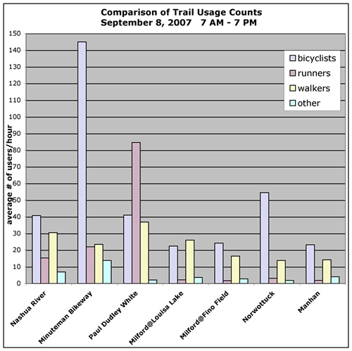
The ratio of runners and walkers to bicyclists also varied for different trails. The Dr. Paul Dudley White Path is a rare off-street option for running in Cambridge. 51% of the users there were runners, 25% were bicyclists. In contrast, only 11% of the Minuteman Bikeway users in Lexington center were runners, 71% were bicyclists. On the Upper Charles Trail, runners constituted only 3 to 4% of all users. while walkers and bicyclists were more evenly divided. Other trails shown on the graph are the Upper Charles Trail in Milford, the Norwottuck Rail Trail, and the Manhan Rail Trail. The locations shown are those for which counts were obtained for the full twelve-hour period.
Upcoming statewide trail usage counts and volunteer opportunities
The next statewide counts are planned for Saturday May 3 and Tuesday May 6.
Volunteers will be needed for 1 or 2 hour blocks of time. No experience is necessary.
Volunteer information is available here.
Help is needed for both weekday and weekend trail usage counts. Volunteers are especially encouraged to help out for the weekday count since we anticipate more difficulty finding volunteers for that time.
Please consider helping out on a trail near you. More information on volunteering will be provided as it
becomes
available.
Related links
John DiMura, NYS Canalway Trail, presented at the Healthy Trails, Healthy Communities Conference, October 2007 Download PDF
Getting a real count of potential Freeman Trail users, Chelmsford Independent
Read the complete article here
|